By Megan Buckley
The current location of Louisiana State University’s campus is rich with history. Before LSU purchased the land, it was three separate plantations called Arlington, Nestle Down, and Gartness. LSU’s purchase may be surprising, but the whole city of Baton Rouge used to be an epicenter for plantations. The banks of Mississippi River provided fertile soil and access to port and shipping routes for plantations to operate.

When looking at this map of the lower Mississippi River, one can see where the three plantations were located along the river, and exactly where LSU’s campus currently sits. Arlington Plantation was owned by C.G. and J. A. McHatton. F. D. Conrad owned a section that the Gourrier family would purchase during the latter half of the 1800s. The Gourrier family added Conrad’s land to their existing property, a plantation named Nestle Down. The third plantation, which was called Gartness, was at the time owned by Smith and McHatton.
Locations of Former Plantations on LSU’s Campus
What is now the central campus of LSU was once the location of the Gartness Plantation’s cabins, storehouses, and master’s house. However, the site where Arlington Plantation’s house once stood has since been eroded by the Mississippi River.
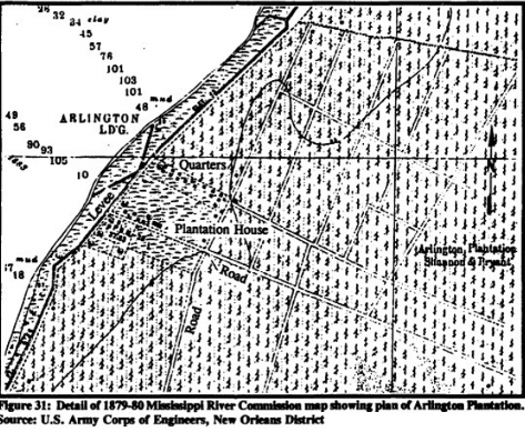
Three maps were featured in a research survey by the US Army Corps of Engineers. One displays Gartness Plantation and features the former plantation house and slave quarters. Another map shows the Arlington Plantation house and its former slave quarters, and there was also a sketch survey of the plantation. These three maps help pinpoint exactly where the slave cabins would have been located on LSU’s campus.
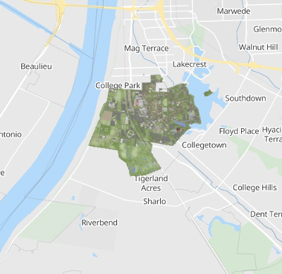
This map of LSU’s campus is a screenshot taken from the LSU Mobile app. The campus map shows where Gartness Plantation’s property lines closely line up with central campus. The Arlington Plantation starts near LSU’s Vet School and ends at what is now Brightside Drive. The Gartness plantation, Magnolia Mound, D. Daigre, and J. H. Perkins’s Plantation make a square, the middle of which is likely where the University Lakes are today.
Arlington Plantation
Over the years, Arlington Plantation was owned by different planters. In the 1830’s, Dr. John C. Williams was the owner. On August 11, 1834, the owners of Arlington Plantation, John Williams and Seth Barton sued each other. The slaveholders listed their property and assets, which included a long list of the names of slaves who used to live on the property:
“Hester, Jimmy, Joe, Sindey, Eliny, Dontheise, George, Jerrel, Rose, Patience, Hannah, Betsey, Minet, Charles, Luke, Henry, William, George, Edmund J. Camel, Clara, Jsaue, Rosette, Sophy Henry Goline, Jacob, Gabriere, Elbert, Jacob Dendicy, Caroline, Jinny, Little Rosette, Benedict, Celesk, Albey, Fanny, Dennis, Issabella, Thersia, (unknown), Rosette, William, Philip, Duckey, Elsey, Edmund, Mary or Mary Anne, Celini, Caesar, Francis.”
The list of slaves was repeated twice in the document. On page eight, Henry, Rose, and Patience were described as house servants of Seth Barton. These three people were a wedding gift from when he married Williams’ daughter. In the document, Barton claimed Dr. Williams tried to count them as part of his property.
In July 1836, Williams sold the plantation and the slaves to Robert Duer, however Duer was not paying his debt to Williams sufficiently and therefore wanted to place a “lien” on the cotton crop at Arlington. He later wanted the crop seized before Duer sold it.

In 1840, Williams reacquired Arlington. At that time the plantation had 62 slaves. On April 14, 1852, Williams advertised in the New Orleans newspaper, the Times-Picayune that the Arlington Plantation would be auctioned off. The property was listed as having 1,100 acres. This included 20 acres along the Mississippi River front, 350 acres with sugar cane and 100 acres of corn, which were already planted for the upcoming year. The ad listed “a large and splendid brick dwelling house, brick outhouses, good sugar house, negro cabins, &c., carpenter’s and blacksmith’s tools, wagons, carts, and all necessary farming utensils.”
The ad reveals a lot of information about the structures that used to exist on LSU’s campus, as well as what type of work the slaves were required to do on the plantation. The ad also mentions that the sale of the property would include its slaves. Thirty-five of them were classified as being “good hands.” All of them, however, would be rented out for the rest of the year.
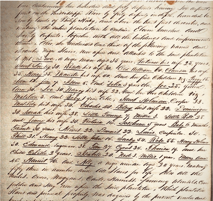
All fifty-three of the slaves who lived at Arlington were included with the plantation’s purchase and were documented in the conveyance record of the sale. The slaves’ names, ages, marital status, and specialized jobs can also be found in the conveyance record. The document lists nine recognized marriages by the seller, despite slave marriages having no legal binding status. Three male slaves had specialized jobs: Edmund the engineer (aged 38), Louis the carpenter (aged 30), and Jacob the cooper (aged 33).
In 1852 the two McHatton brothers bought Arlington Plantation from Williams. The two brothers owned a lot of property in Baton Rouge including Gartness and Arlington Plantations, as well as the old Louisiana State Penitentiary, which was in Downtown Baton Rouge between Laurel Street and Florida Street. After 1857, James A. McHatton was the sole owner. On December 12, 1862, (during the Civil War) James McHatton and his wife fled to Texas, and then later made their way to Cuba to start a new sugar plantation.
Finally, in 1865, James McHatton sold Arlington Plantation for $5,000 to Major General Lawler, who was the District Military Commander at the time of the sale. The plantation was sold for a very low price, which was acknowledged in the sale notice. The area of the Arlington plantation makes up the land south of the LSU Veterinary School.
Nestle Down Plantation
Little information can be found about Nestle Down Plantation. The Gourrir family purchased the property from F. D. Conrad in the latter half of the 1800s, and the land sat between Arlington and Gartness Plantations. The slender section of land on Norman’s Map coincides with where the street named Gourrir Avenue is today. Gourrir Ave. is a modern marker for where the border of Arlington Plantation and F.D. Conrad’s former property used to be located.

Gartness Plantation
The Norman’s Chart lists Smith and McHatton as being owners of Gartness in 1858. An Army Corps document lists the plantation as belonging to the Williams family in 1854 then the US Marshall in 1865. In 1879, the plantation was again owned by the Williams family. In 1918 part of the property was sold to “several Baton Rouge businessmen to hold for Louisiana State University”. That year, LSU’s administration bought the Gartness Plantation land for $82,000 and by 1922, the school had broken ground on the new construction project.
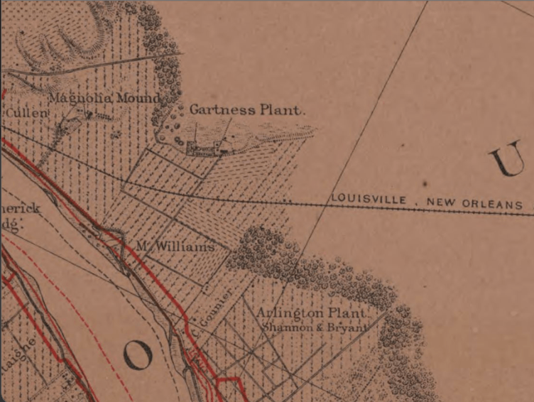
In this map, the Gartness Plantation buildings and slave cabins are featured. This map also features the Louisville, New Orleans, & Texas Railroad. In 2021, when looking at the relation of the railroad line, one can locate Tiger Stadium. Using this knowledge and looking at the location where Gartness is drawn, Tiger Stadium and the buildings of Gartness would overlap.
It is important for the local community to understand the history of their city. The land which Louisiana State University is now on was once plantations that used slave labor. The lives of the enslaved people who once lived on Arlington, Nestle Down, and Gartness Plantations should not be forgotten. It is important to identify that plantation slavery was prevalent in the area during the Antebellum Era and that these plantations had an impact that can still be seen throughout modern Baton Rouge. Names such as Arlington and Gourrir are still used throughout the area in the locations where the former properties of these plantations existed.
Sources
- John C. Williams v. Seth Barton, August 9, 1834, 3rd Judicial District Court, Louisiana Supreme Court Archives: 6-8, https://dspace.uno.edu/xmlui/handle/123456789/39863.
- Map of LSU’s Current Campus, retrieved April 20, 2021. LSU Mobile App. Screenshot by author.
- Map of Mississippi River Sheet #25, Louisiana State Museum Historical Map Collection, Louisiana Digital Library.
- Norman, Benjamin Moore, Norman’s Chart of the Lower Mississippi River, 1858, http://hdl.loc.gov/loc.gmd/g4042m.ct000765, Library of Congress.
- Persac, Marie Adrien, 1823-1837, Map 18, CD #6, Louisiana State University Libraries Special Collections.
- Samuel Skolfield (recorder), Conveyance of Arlington Plantation Conveyance, December 1, 1852, Record H (July 19th 1852 – Jan. 11th 1854), page 119, Baton Rouge Clerk of Court.
- Tri-Weekly Gazette & Comet, Sale of Arlington Place near Baton Rouge, Louisiana in 1865, August 10, 1865, Louisiana Works Progress Administration (WPA), Louisiana Digital Library, https://louisianadigitallibrary.org/islandora/object/state-lwp%3A1428.
- U.S Army Corps of Engineers, “A Cultural Resources Survey of Arlington Revetment and LSU Berm Levee Improvement Item, East Baton Rouge Parish, Louisiana,” Cultural Resources Series no. COELMN/PD – 91/01, (July 1993): 73-78, 89, 146, https://apps.dtic.mil/dtic/tr/fulltext/u2/a278933.pdf.
- William Waller Survey Collection, Mss. 3592, 3910, 4326, Louisiana and Lower Mississippi Valley Collections, LSU Libraries, Baton Rouge, La., https://louisianadigitallibrary.org/islandora/object/lsu-sc-p16313coll57%3A126.
